- Little Forests Kingston
- Posts
- Explore the City's Tree Data
Explore the City's Tree Data
Plus: The importance of Maple Syrup for Indigenous communities

Happy Ziizbaakdoke-giizis (Sugaring Moon)! This moon is named for the time when the Sugar Maples’ sap begins to run. Much like Mnoomin (wild rice), which we talked about last Fall, Ninaatigwaaboo (maple syrup) has been an important part of the diet of the Anishinaabe, Haudenosaunee, and other Indigenous peoples across Turtle Island. Despite the labour required to produce it, Indigenous families and communities put in a great deal of effort each year to produce the syrup. Even the European missionaries realized this, as described here by Hanipaux from the Holy Cross Mission in Wikwemikong (on Manitoulin Island):
For the last two months, here, our native people have been busy in the woods making maple sugar. They return laden with an extraordinary amount of it. The village of Saint-Croix alone, which has 80 to 100 families, collected 80,000 pounds of it. This would be very profitable for them if, instead of exchanging it for almost nothing, they could sell it at its fair price. The merchants with whom they deal claim, it is true, to buy the sugar from them at eight or nine cents a pound. But when it comes to paying them, instead of money they give them fabrics to which they attach any price they please, so that in the end the poor native receives only three or four cents for a pound of sugar.
To make this sugar however, had been extremely difficult. [They] had to spend about two months continually in the snow and close to the fire. At the beginning, our people are in the snow to collect the sap that flows drop by drop from the notches they have made in the trees. Below these openings they place small bark cups they have in large numbers and are always on the run to see if these cups are full and then pour them into large tubs. Once this sap is collected, it must be brought to a boil; practically all of it is dissipated in steam.
A barrel of sap yields perhaps one pound of sugar and this sap must be further reduced to the point that a pound of sugar is all that remains. When it is thus reduced, it has to be beaten to reduce it into solid chunks. They continually feed a large fireplace to make the sap boil and to reduce it into steam.
[...]
Despite all this hard work, these good people are satisfied when they have made a large amount of sugar. It is the sole object of trade that they have, with the exception of the fish some of them sell to the merchants.
For context, 80,000 lbs is roughly equivalent to two fully-loaded semi trucks full of maple sugar!
Although the Indigenous families were scammed out of their maple sugar by the European traders, they knew that what they made was valuable, and Maple Bushes became one way that the Indigenous peoples negotiated in treaties with the colonists:
My Brother I am happy to see you today in daylight. This is what I have always wanted. I said to myself: “Would that I may see the one who is in charge, so that I understand him and he understands me.” Listen my brother to what my chiefs say through me: Is it really now, when good fortune is beginning for the native, is it now that you have come to ask him for all his land! Be careful! Those natives who ceded the mainland [referring to Robinson Huron Treaty 1850] have not yet received any of the money that you promised to pay them. You promised them four piastres; now, see this (pants); they cost me four piastres, but I did not get them with what you gave for my land. It is the sugar that I take from the trees on my little island that gave them to me [emphasis added]. Look at me, brother, I am a chief from the mainland that my father ceded to the Great Woman Chief. If my father had come here, he would have spoken. I am not ashamed to reveal my misery to you. One thing amazes me. It is that the Great Woman-Chief comes to ask us for our property! Is she so poor? Does she not have abundant treasures over there in the land they call England? But we who have abandoned our property, we are unfortunate! Brother, understand my thoughts and those of my chiefs: we do not surrender any of our land.
Maple Syrup is an inherently anti-commercial product in Indigenous cultures as well, as is told Andrew J. Blackbird’s (Odawa from modern-day Harbour Springs, Michigan) 1887 recounting of the story of Nanabozhoo (here named “Ne-naw-bo-zhoo”):
Ne-naw-bo-zhoo, was the most remarkable, wonderful, and supernatural being that ever trod upon the earth. He could transfigure himself into the shape of all animals and live with them for a great length of time. He has done much mischief and also many benefits to the inhabitants of the earth whom he called “his nephews” and he shaped almost everything, teaching his nephews what materials they should take for their future utensils. This mischievous Ne-naw-bo-zhoo spoiled the sugar trees by diluting their sap with water. The legends say, that once upon a time the sugar trees did produce sap at certain season of the year which was almost like a pure syrup; but when this mischievous Ne-naw- bo-zhoo had tasted it, he said to himself, “Ah, that is too cheap. It will not do. My nephews will obtain this sugar too easily in the future time and the sugar will be worthless.” And therefore he diluted the sap until he could not taste any sweetness therein. Then he said, “Now my nephews will have to labor hard to make the sugar out of this sap, and the sugar will be much more valuable to them in the future time.
Most of what I’ve written here about Maple Syrup comes from a longer article by Alan Ojiig Corbiere from the M’Chigeeng First Nation, which I encourage you to read in full here.
Announcements
What do you do when you have a very constrained space and you want to plant a Pocket Forest? Find out in our new article about planting trees near power lines.

Trees and Flowers in Churchill Park, Kingston, Ontario
Exploring Kingston’s Tree Inventory
I recently heard from Oliver Reichl, who works for the City and is also on our board, that Kingston has released a new dataset for “City-owned trees”. I’m always curious to see what the data shows, so I figured I’d do some digging and see what I could find!
Data
The City’s tree inventory is a set of more than 50,000 geolocated records of trees which the City owns. They are located in boulevards (the space between the road and the sidewalk, usually), in City parks, and in other public places. This means that the data doesn’t include places like schools, private properties, or conservation areas (you’ll notice that the Lemoine Point area is pretty empty).
Each tree has some data attached to them, including their species, the diameter of their trunk (“diameter at breast height” or DBH), and, if they have died, the date that they were designated as dead. I went through the dataset myself and also added whether each species was native, non-native, or unspecified (in some cases, the trees were listed by their genus, e.g. Maple, rather than their specific species, e.g. Sugar Maple).
Objectives
The main purposes of analysing the City’s dataset were:
To determine which areas of the City are performing the best and worst in terms of 3-30-300
To identify the areas in the city which have the greatest need for new tree plantings
But I must admit, I started off browsing the data just to find some fun facts to share, so you’ll also see some unrelated discussion below :)
Methodology
(Skip this section unless you’re really interested in data)
To process the data, I used the open-source GIS (“geographic information system”, which is basically just putting data on a map) software QGIS, which I have a fair amount of experience with. You’ve probably used a GIS interface before, because most open geographic data is hosted on ArcGIS, which is the most widely used GIS platform and is also paid (which is why I don’t use it).
I decided to use a few different ways of analysing the data. First, I used a heatmap,which gives you a general idea of the density of trees near any given point. I broke the data down into trees in parks (to estimate the “300 m from a quality green space” component of 3-30-300) as well as by non-park trees (to look at the general canopy cover).
Besides general tree density, I also wanted to look at specific aspects about the trees, such as their species and sizes, but since I wanted to look at those independent of the general density of trees, I split the city up into a grid of squares as well as by voting district (I couldn’t use a heatmap for that because those variables are independent of the tree density). I clipped the grid and the voting districts to the city’s urban boundary, because in the more rural areas of the city, there aren’t very many data points.
The Results
Map 1: Tree Density


For these heatmaps, I used a radius of 300 m, meaning that the colours you see represent the density of trees within 300 m from any given point. The first map has no filter on the data (except to remove dead trees), and you can see that locations near well-treed parks, such as Lake Ontario Park, City Park, Auden Park, and Snider Park, come up as having a much greater density of trees. At this point, you’ll notice that certain locations are outside the City’s jurisdiction (Lemoine Point, Belle Park/Island, Fort Henry/RMC, Novelis, etc.), so it’s important to keep that in mind when looking at the map.
If we want to look more specifically at the “300 m from a quality green space” component of 3-30-300, we can filter out all trees that aren’t in parks or along trails, which is what you see in the second map. This map is SUPER interesting because you can clearly see where the gaps are in the City’s tree network. Some residential areas are more than 300 m away from ALL parks or trails with trees. This map suggests that Greenwood Park is actually the most well covered of any area in the city, which is mainly because of the Greenwood Park trail which runs along the edges of the neighborhood, but they also don’t necessarily have a high density of park/trail trees anywhere. Despite its proximity to City Park, Lake Ontario Park, and other well-treed parks, Queens Campus represents a pretty big gap, along with a few other specific areas around the city. The Gardiners Road/Development Drive/RioCan Centre area is another gap, which is not surprising but definitely deserves addressing.
Now, if we look at the third map, we can get a feel for the “30% canopy cover” component of 3-30-300, since it shows the amount of tree cover we have along streets and in public spaces. Here, we see that Greenwood Park performs quite well, as well as the downtown area, the Cat Woods/Woodhaven area, and the Cataraqui North/Crossfield neighborhood. The biggest gaps in the canopy cover occur around major roads, with the north-south corridor of Gardiners Road and Days Road being the worst culprit, but also Bath Road, Princess Street, and John Counter Boulevard.
Map 2: Proportion of Native Trees


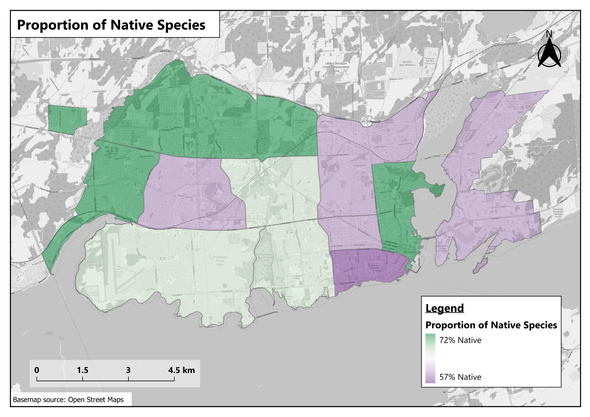
For this section, and the next sections, we’ll be switching over to the grid and district maps for the most part, although I’m still going to include a heatmap to give you another perspective on the locations that have native species. Any spot where there is colour means that a majority of the plants within 300 m are native, whereas gaps in colour indicate that non-native trees are more common than native trees. The heatmaps show that the vast majority of parks and trails have a greater presence of native species than non-native species, although some parks perform less well on this metric, most notably City Park, which appears to have quite a lot of non-native trees. When we look at the street trees and public realm, though, the same definitely can’t be said. Many places that are well-covered with trees show widespread dominance of non-native species, including in Greenwood Park, which has very solid coverage from trees but has a significant lack of native species, as well as the western part of the Auden Park neighborhood, Calvin Park, Kingscourt, Rideau Heights, and, of course, along Gardiners Road.
When we look at the grid and district analyses, most locations have a majority-native tree population, although in many cases only by a small margin. The most notable exception is the Acadia Drive area on the west side of Bayridge Drive, near the airport, which has an overrepresentation of non-native tree species. Looking at the data, the street trees planted in that area include a large number of Norway Maples and Littleleaf Lindens. Based on historical satellite and street view imagery, it seems like the trees may have been planted around the early 2000s, around the start of the Emerald Ash Borer infestation, and considering that a decent portion of the native trees in the neighborhood’s dataset are now-defunct Ash trees, these non-native species may have been planted as a convenient and quick (but perhaps not well thought-out) solution to the impending dangers for Ash trees.
At the district level, all areas have majority native species for their trees, with values ranging from 57% to 72% native. The downtown area appears to have the largest proportion of non-native species. It seems like this is because of a generally higher prevalence of non-native street trees in this area, with a lot of Norway Maples and Littleleaf Lindens, similar to the Acadia Drive area, along with Austrian/Black Pines, Japanese Lilacs, and Gingkos (which, rather ironically, are endangered in their native habitat but are easy to find in most North American cities). Plus, as we noticed above, City Park has a fair number of non-native trees as well. The north and east ends of the city face similar problems with a large proportion of street trees consisting of non-native species.
Map 3: Species Diversity


At the grid level, species diversity can be as low as 15-20 species and as high as an impressive 95 species in a single square kilometre. Of course, the data may be misleading for some cells because of a low or high number of trees, but generally, we see a large number of different tree species in locations with parks, which also tend to be the cells that have high numbers of trees, with diversity decreasing in locations with fewer trees. But that’s not the case for all cells, and certainly not for the darker green cell in the Strathcona Park area, which has a staggering 79 different tree species despite not having any large parks. The street trees in this area include all sorts of species, ranging from the American Basswood to Blue-Beech to one of only three records of Apricot trees and the only two Swedish Whitebeams in the City’s records (neither of which are native but it’s still interesting!).
At the district level, species diversity ranges from 100 to 130, which suggests that the districts generally have a fairly high level of diversity. There aren’t any major outliers; the Trillium district has the lowest diversity (probably due to the commercial/industrial zone around Gardiners road that is pretty sparsely treed), and the Portsmouth district has the highest.
Maps 4 & 5: Average Trunk Diameter & Dead Trees Recorded


I figured I’d cover these two maps at the same time, since I suspect there is quite a bit of correlation between the two. At the grid level, you’ll probably notice immediately that one cell contains exclusively dead trees. The cell only includes 3 records, and they are all dead Ashes, so there’s not much to be said. Most of the land is owned by the Prison, so there are few records there. You may also notice that a couple of the locations with the smallest trunk sizes are in the middle of the pack when it comes to the proportion of dead trees recorded by the City. These two locations only have trees that are growing along major streets (namely Bath Road and Centennial Drive), with no trees in residential neighborhoods. Trees in those kinds of environments tend to be exposed to very harsh conditions (road salt, damage from vehicles pushing snowbanks onto them, trampling by pedestrians, lack of biodiversity, neglect, etc.) which means that they often die while they are still young, and are subsequently replaced by new trees that suffer the same fate.
At the district level, you can see a lot more correlation between the two maps. The most obvious district is the Collins-Bayridge district, which has the highest average diameter at breast height (DBH) for any district, and also has the highest death rate at 20% of records. Conversely, the Loyalist-Cataraqui district has the lowest average DBH and has only a 14% death rate. One outlier district is King’s Town, which has an average DBH somewhere in the middle of the pack, at roughly 24 cm, and has the second highest death rate at 19% of records. The Trillium district exhibits an inverse trend, with a 28 cm average DBH but only 13% of records showing dead trees.
Conclusions
We learned a lot today, and I think this analysis has given us some ideas in terms of which neighbourhoods we should focus on for our Pocket Forests and Little Forests. They mostly line up with areas we had already noticed on the Rusty-Patched Bumblebee map that we make for the annual report:
Auden Park
Rideau Heights/Kingscourt, especially near the railroad tracks
Anywhere along Gardiners Road/Days Road
I didn’t mention some areas because they have a strong presence of Little Forests and/or Pocket Forests.
Beyond the 3-30-300 analysis, another interesting piece of information is just how many Norway Maple trees we have on our streets. Across the whole dataset of just under 54,000 trees, 5,775 records are of Norway Maples, meaning that they make up over 10% of the City’s trees - that’s huge, especially when you consider that they are generally quite short-lived, with a typical lifespan of around 20 years. That means that by 2046 we will likely have had to replace 10% of the entire City’s tree inventory. I also found the DBH/Tree death analysis to be quite interesting, with major roads struggling to keep trees alive and well-maintained.
If you’d like to explore the data yourself, you can get it from the City’s Open Data portal, and I also made a map that you could use if you wanted to see the different tree species in specific areas of the city.
– Robert